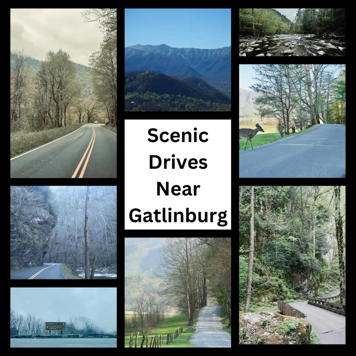
Gatlinburg has some amazing scenery nearby, including places you don’t need a long hike to see. Here’s our favorite drives that let you explore the Smoky Mountains. without leaving…
By Shandi
Travel Expert
Updated July 4, 2026
Gatlinburg has some amazing scenery nearby, including places you don’t need a long hike to see.
Disclosure: We partner with Smoky Mountain Vacation Cabins.
Use code TSMFRIENDS for exclusive discounts on your cabin rental.
Here’s our favorite drives that let you explore the Smoky Mountains. without leaving your car. We live here and driven all of them.
These drives are all close enough to do as a partial day trip from Gatlinburg, or Pigeon Forge.
It’s not an exhaustive list, but driving these four will give you the best of the Smoky Mountains without taking you too far from Gatlinburg or Pigeon Forge. We’ve excluded some that start too far away.
They will also let you see about everything: high altitudes, mountains, valleys, rivers, historic buildings, and wildlife.
If you don’t have time to do everything, try to see Roaring Fork and Cades Cove (or Newfound Gap). The drive to Cades Cove also allows you to drive Little River Rd along the way.
For travelers using Roaring Fork as an older-feeling Gatlinburg reset, this reader guide explains where that feeling still shows up.
Scenic Drives NEar Gatlinburg
Roaring Fork Motor Nature Trail
Distance from Gatlinburg: 7 minutes. Duration: 1 hour minimum, without traffic
Roaring Fork Motor Nature Trail. Photo by Ashley @ TheSmokyMountains.com
Just a couple minutes from Gatlinburg is some of the best scenery in the Great Smoky Mountains: the Roaring Fork Motor Nature Trail.
Cabin on Roaring Fork. Photo by Ashley @ TheSmokyMountains.com
This scenic one-way, one-lane road is a 5.5-mile loop with great views of streams, forests, and historic buildings like cabins and a mill.
Overlook from Roaring Fork. Photo by Ashley @ TheSmokyMountains.com
Two overlooks offer great views, though both parking lots are small and it can be hard to find a spot.
It’s also a great place to spot some black bears, we usually see both bear and deer each time we visit.
Narrow road along drop-off. Photo by Ashley @ TheSmokyMountains.com
Roaring Fork is closed during winter, and it’s a narrow road, so no RVs or other trailers.
Stream Through Roaring Fork. Photo by Ashley @ TheSmokyMountains.com
Just before starting the loop, stop at the Noah “Bud” Ogle cabin nature trail. It’s right by the road and a short walk from the parking lot.
Ogle Cabin. Photo by Ashley @ TheSmokyMountains.com
The trailhead for Rainbow Falls, a 5.4-mile roundtrip hike to an 80-foot waterfall, is at the start of the Roaring Fork loop.
Want free help planning your Smoky Mountain vacation? Join the new Smoky Mountains Forum and our Facebook Page. We’re there every day to answer questions!
Newfound Gap Road
Distance from Gatlinburg: Starts just outside Gatlinburg, 30 minutes to Newfound Gap overlook. Duration: Several hours to all day, depending on how far you go.
Newfound Gap road in Spring. Photo by Ashley @ TheSmokyMountains.com
It can be a several hour journey to Newfound Gap Overlook and back, or an all-day adventure that takes you to the highest peak in the Smoky Mountains, and if you keep going gives you a chance to see Elk at the south visitor center.
Cloudy day on Newfound Gap Road. Photo by Ashley @ TheSmokyMountains.com
Starting just outside Gatlinburg, the road winds up the mountain with great stops for viewing and overlooks along the way.
It’s worth the drive even with cloudy skies like in many of these pictures.
Mountains covered by clouds on Newfound Gap Road. Photo by Ashley @ TheSmokyMountains.com
This route takes you to some of the highest elevations in the Smoky Mountains, where you’re more likely to find snow in the winter.
Newfound Gap Road tunnell. Photo by Ashley @ TheSmokyMountains.com
You’ll even cross paths with the Appalachian Trail.
Eventually, you’ll reach Ben Morton Overlook and Newfound Gap Overlook.
Newfound Gap Overlook. Photo by Ashley @ TheSmokyMountains.com
There’s a good amount of parking at Newfound Gap, though don’t be surprised to find it full on a busy day!
Newfound Gap Overlook parking. Photo by Ashley @ TheSmokyMountains.com
From Newfound Gap you can return to Gatlinburg, OR (highly recommended) keep going to Clingmans Dome.
You can also keep going towards Cherokee, NC for some Elk viewing.
Sign on Newfound Gap Road. Photo by Ashley @ TheSmokyMountains.com
From Newfound Gap continue to Clingmans Dome, the highest point in Tennessee (and the Smoky Mountains!).
From the Clingmans Dome parking lots, it’s about a half-mile paved uphill walk to the observation tower.
Path up to Clingmans Dome. Photo by Ashley @ TheSmokyMountains.com
It’s not a hard hike, but it’s fairly steep and if you’re used to sea level elevation you may find yourself stopping for a break on the way up.
Clingmans Dome Overlook on a cloudy day. Photo by Ashley @ TheSmokyMountains.com
The views at the top are great, even on a cloudy day you may luck out and be above some of the cloud layers
Clingmans Dome on a cloudy day. Photo by Ashley @ TheSmokyMountains.com
On this visit near the end of April in 2024, we found a few minutes of some pretty heavy snow with a temperature of 39 degrees.
Snow at Clingmans Dome in April. Photo by Ashley @ TheSmokyMountains.com
The temperature back in Gatlinburg was almost 60.
From Clingmans Dome or Newfound Gap, you can also continue towards Cherokee and stop at the Oconaluftee Visitor Center.
Road new Smokemount Campground near Cherokee, NC. Photo by Ashley @ TheSmokyMountains.com
The scenery starts to look different as you get closer to Cherokee, ending with some wide open fields near Oconaluftee Visitor Center.
Elk in the field next to Oconaluftee Visitor Center. Photo by Ashley @ TheSmokyMountains.com
The Oconaluftee Visitor Center is one of the best places to see Elk, especially in the morning, evening or on cloudy & rainy days.
In the picture above, there were 4 or 5 Elk standing just a few feet away from the main road when we drove by.
Little River Gorge Road
Distance from Gatlinburg: 20 minutes. Duration: 1-2hrs, ends near Cades Cove.
Map of Little River RdLittle River. Photo by Ashley @ TheSmokyMountains.com
Little River Gorge Road, which winds alongside the Little River, is a quiet, slow-paced drive with plenty of places to pull over and take pictures, or even get into the river.
On the drive from Gatlinburg to Cades Cove, this will be one of the routes offered by Google Maps (the one with all the sharp turns).
Rocky overlook that looks like a face along Little River Road. Photo by Ashley @ TheSmokyMountains.com
The road follows the river, with some a rock wall on the other side of the road.
Ticket Deals
Tickets in Gatlinburg
The Sinks waterfall. Photo by Ashley @ TheSmokyMountains.com
This waterfall (The Sinks) is easily accessible from the road.
Little River. Photo by Ashley @ TheSmokyMountains.com
Little River Road ends at the Townsend Wye (where two river branches join).
Townsend Wye where the river splits. Photo by Ashley @ TheSmokyMountains.com
Cades Cove
Distance from Gatlinburg: 1 hour and 15 minutes. Duration: 2 hours or more once you get there, depending on how many stops you make. “Bear jams” often occur, where traffic comes to a standstill when bears make an appearance.
Cades Cove. Photo by Ashley @ TheSmokyMountains.com
Cades Cove is an 11-mile loop and offers one of the best scenic drives that combines natural beauty, wildlife encounters, and historical landmarks.
It’s one of the most well known, and popular things to see in the national park.
Cades Cove. Photo by Ashley @ TheSmokyMountains.com
Cades Cove does get busy, but it’s still one of our favorite scenic loops. It’s a one-lane loop that usually moves pretty slowly and takes several hours to get around on a busy day.
There are some great places to stop and explore the older buildings.
Church at Cades Cove. Photo by Ashley @ TheSmokyMountains.com
If you’re up early, Cades Cove is also a beautiful place to see at sunrise.
It’s a great place to spot black bears, turkeys, and deer. We’ve seen deer every time we’ve been, and bears are likely to be found in late afternoon and evening.
Deer at Cades Cove. Photo by Ashley @ TheSmokyMountains.com
In the picture above, we had pulled over to take pictures when this deer crossed the road and walked about 5 feet in front of us.
Foothills Parkway
Distance from Gatlinburg: 30 minutes. Duration: One hour and up. Foothills Parkway doesn’t require as many stops as the other routes, as there’s not much to stop at.
Note: If you’ve already driven the scenic drives above, don’t feel bad if you miss this one.
Foothills Parkway offers nice mountain views. You’ll often find people stopped for picnics or just to take in the scenery.
Foothills Parkway bridge. Photo by Ashley @ TheSmokyMountains.com
This is a newer road takes that takes you high above Townsend and Wears Valley.
As you can see on the map, it continues pretty far away from Gatlinburg. These pictures are just from the section between Wears Valley and Walland.
Map of Foothills Parkway
A good round trip from Gatlinburg is to take the Foothills Parkway west from Wears Valley until the first exit (Walland), then on the way back, take the valley through Townsend.
View from the road on Foothills Parkway. Photo by Ashley @ TheSmokyMountains.com
There are parking areas at the different overlooks on the Parkway, usually with plenty of parking spaces.
The road, being new, is also wider and less curvy than many other mountain roads around, some of which can be a wild ride.
View from the overlook on Foothills Parkway on a rainy day. Photo by Ashley @ TheSmokyMountains.com
Conclusion
We hope this guide was helpful. Let us know in the comments or on our new forums.
Planning a trip to Gatlinburg?
Save what's useful here, then check stays before dates fill up.